LY Flay
DJI Mavic 3M Multispectral – Professional Agricultural & Mapping Drone
DJI Mavic 3M Multispectral – Professional Agricultural & Mapping Drone
Couldn't load pickup availability
DJI Mavic 3 Multispectral (Mavic 3M)
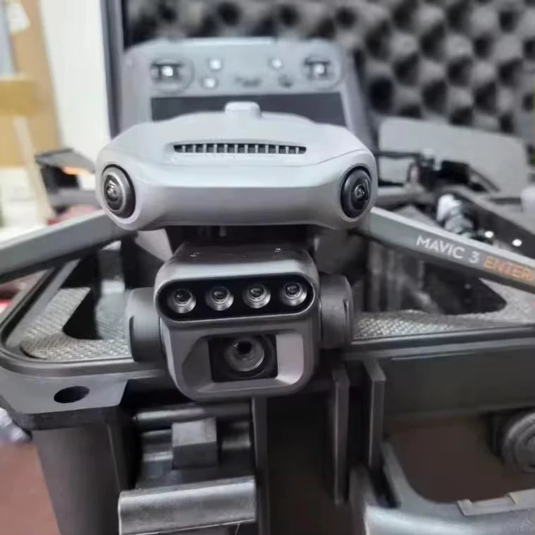
A professional-grade drone built for precision agriculture, surveying, and environmental monitoring. Equipped with both an RGB and a multispectral camera, it enables detailed crop health analysis, NDVI mapping, and resource management with exceptional accuracy.
✨ Key Features
📷 Dual-Camera System — Combines RGB and multispectral imaging for comprehensive crop and terrain data.
📡 Long Transmission Range — Stable image transmission up to 15 km.
⚡ Efficient Performance — Flight time up to 20 minutes, ideal for quick field scans.
🎮 Smart Control — Remote control with one-key takeoff and landing.
📦 Foldable & Portable — Compact design for easy transport and deployment.
🔧 Professional-Grade — Optimized for agricultural and mapping professionals.
📋 Specifications
| Parameter | Details |
|---|---|
| Model | DJI Mavic 3 Multispectral (M3M) |
| Camera | RGB + Multispectral |
| Transmission Distance | Up to 15 km |
| Flight Time | 10–20 minutes |
| Control Method | Remote Controller |
| Design | Foldable |
| Use | Agriculture, Mapping, Monitoring |
| Type | Commercial Drone |
| Brand | DJI |
📦 Package Includes
-
1 × DJI Mavic 3 Multispectral Drone (M3M)
-
1 × Remote Controller
-
Standard Accessory Set
🌾 Applications
-
Precision Agriculture (NDVI, crop health analysis)
-
Surveying and Mapping
-
Land and Resource Monitoring
Share